
 Español
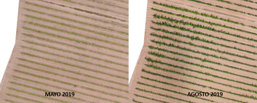
Multi-temporal study in vineyard
Vigour controlling? Detection of Wood illnesses? Yield estimation? Thanks to multi-temporal studies development it is possible to answer these questions.

Vigour controlling? Detection of Wood illnesses? Yield estimation? Thanks to multi-temporal studies development it is possible to answer these questions.
Vine cultivation is one the most important ones and with a highest socio-economic impact in our country with a total area of 941.515 (Magrama, 2018). For this reason, it is vital to know our cultivation state in each phenological moment, being able to act as quickly as possible in the event of any unforeseen event, minimizing possible final production loss.
It is unfeasible for the farmer to have to walk all over his farm periodically to check the health of his crop. This is where the role of remote sensing comes into play, as through satellite images and drone images, we can monitor the vigour and health of the crop accurately and continuously over time.
These images help to characterise the intra-plot vegetative state and to plan the areas where green pruning or thinning should be carried out.
They also provide information about some of the major infectious agents in the vineyard, such as wood diseases.
But… what are wood diseases? They are a group of fungi that attack the vine, and can attack the trunk and the branches of the vines, in the aerial part; or the roots, in the underground part. These xylophagous fungi can enter the vine through pruning wounds, and can descend towards the base of the plant. Leaf symptoms can take time to be identified by the technician but, thanks to remote sensing, we can detect physiological changes in the vine that show that it is suffering some kind of stress, due to the incidence of a fungus or even water stress.

Obviously, we must not forget that the use of remote sensing must bring benefits in the final production. For this reason, obtaining multispectral information in the veraison phase is essential for the zoning of the plot and to be able to carry out a selective harvest, based on the quality we want to obtain..
In addition, obtaining thermal maps during the veraison phase will allow us to evaluate the water status of the vines and to plan irrigation for the ripening phase of the bunches.
Therefore, the use of remote sensing through temporal analysis of the crop can reduce the use of pesticides, optimise water resources or help in estimating sales weeks before harvesting.